Krakatoa
Krakatoa, a name that evokes both awe and fright, lies nestled in the Sunda Strait, precisely between Java and Sumatra in Indonesia. This stratovolcano has intrigued geologists and historians alike, owing to its prominent geological features and its infamous past. Krakatoa’s location plays a crucial role in its characterization as a pivotal point of volcanic activity in the region. Surrounded by the rich biodiversity of the Indonesian archipelago, the volcano is part of the Pacific Ring of Fire, an area known for its tectonic instability and significant seismic activity.
The significance of Krakatoa in the geological landscape cannot be overstated. Its formation began approximately 2,500 years ago, culminating in its most famous eruption in 1883, which shaped both the physical geography of the region and human experience. The eruption was incredibly powerful, resulting in one of the deadliest volcanic events in recorded history. It released immense amounts of ash and pumice into the atmosphere, leading to climate changes and spectacular sunset phenomena observed worldwide. The historical accounts of this event illustrate how natural processes can impact not only local environments but also global climatic conditions.
Krakatoa’s notoriety extends beyond its geological implications; it serves as a potent reminder of nature’s volatile beauty. The stories surrounding its cataclysmic eruptions resonate through time, underscoring the relationship between humans and the natural world. Today, it remains an active research site, as scientists continue to study its behavior and the geological forces that shape it. The fascination with Krakatoa persists, as it embodies the dynamic power of the Earth’s geology that has intrigued civilizations for centuries.
Geological Features of Krakatoa
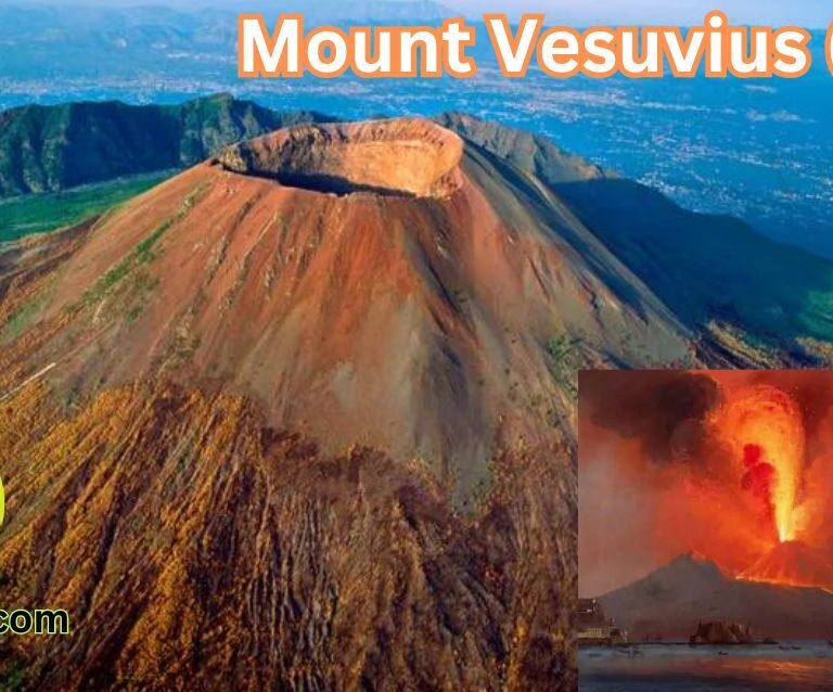
Krakatoa, a prominent stratovolcano located in the Sunda Strait between Java and Sumatra, is renowned for its explosive history and stunning geological features. This formation typifies the characteristics of stratovolcanoes, which are characterized by their steep profiles and alternating layers of lava flows, ash, and tephra. Over millions of years, these geological processes have sculpted Krakatoa, creating a complex landscape marked by a variety of volcanic activities.
The physical appearance of Krakatoa is highlighted by its conical structure, which rises dramatically from the surrounding ocean. The original island of Krakatoa was the result of significant volcanic activity, but it was largely destroyed during the catastrophic 1883 eruption. This eruption was one of the deadliest in recorded history, resulting in the collapse of the volcano, leaving behind a caldera that partially submerged the island. Subsequent eruptions led to the emergence of Anak Krakatau, or “Child of Krakatoa,” which now exists within the caldera and continues to grow due to ongoing volcanic activity.
The geological processes that shape Krakatoa are deeply intertwined with the theory of plate tectonics. The movement of tectonic plates in this region, particularly the convergence of the Eurasian and Indo-Australian Plates, creates significant pressure and causes magma to rise, resulting in volcanic eruptions. These dynamic processes not only influence Krakatoa’s activity but also contribute to the creation of other notable features in the region, such as volcanic islets and the fertile soils that support diverse ecosystems. Understanding the geological characteristics of Krakatoa is vital for comprehending not only its past eruptions but also its potential for future volcanic events.
A Historical Overview of Eruptions
The history of Krakatoa is marked by a series of significant volcanic eruptions that have shaped its identity and the surrounding regions. Notable eruptions date back centuries, with records indicating activity as early as the 416 AD eruption. However, the most catastrophic event occurred in 1883, a date etched into the annals of natural disaster history. This eruption was not only one of the most powerful volcanic eruptions ever recorded but also resulted in widespread devastation and loss of life.
Leading up to the fateful eruption, seismic unrest had been noted in the region. Local inhabitants observed unusual volcanic activity and rumbling sounds, yet the magnitude of the impending disaster was largely underestimated. On August 26, 1883, Krakatoa erupted with an unimaginable ferocity. The series of explosive events produced ash clouds that reached the stratosphere and generated tsunamis exceeding 30 meters in height, devastating coastal communities in nearby islands such as Java and Sumatra.
In the immediate aftermath, the eruption killed tens of thousands of people; estimates suggest that around 36,000 lives were lost due to the explosions and resulting tsunamis. The eruption also had a prolonged effect on the planet’s climate, leading to a drop in global temperatures and causing stunning sunsets that were global phenomena, inspiring artists and scientists alike for years to come.
The consequences of the 1883 eruption of Krakatoa extended beyond the immediate death toll and environmental impact. The event raised awareness of volcanic activity’s potential for catastrophe, prompting advancements in seismology and disaster preparedness in the decades that followed. Furthermore, it remains a crucial point of study for volcanologists seeking to understand the complexities of volcanic eruptions and their effects on humanity and the Earth.
The Catastrophic Eruption of 1883
The eruption of Krakatoa in 1883 stands as one of the most catastrophic volcanic events in recorded history. This eruption unfolded from August 26 to 27, 1883, and it was marked by a series of violent explosions that reverberated across the globe. The eruption began with a series of relatively small explosions, but these soon escalated into colossal detonations that were heard as far away as Australia and the island of Rodrigues near Mauritius, located approximately 4,800 kilometers away.
The most devastating aspect of the 1883 eruption was not merely the explosions but the resulting tsunamis that followed. Heightened seismic activity triggered massive waves that swallowed coastal towns in the Sunda Strait, with some estimates suggesting wave heights reaching up to 40 meters. These tsunamis obliterated entire villages, causing immense devastation and loss of life, with an estimated 36,000 people killed in the disaster.
The impacts of the eruption were not confined to local tragedy; they reverberated around the world. The ash and debris ejected into the stratosphere influenced global temperatures, leading to significant climatic changes for years to follow. Reports from various regions mentioned unseasonably cool weather, with the year 1884 marked by a phenomenon referred to as “volcanic winter.” Such climatic alterations affected agricultural output and altered ecosystems, demonstrating the far-reaching implications of the eruption.
This cataclysmic event irrevocably changed the landscape of the region, as well as the lives of the local population and their cultural practices. Communities were left devastated, facing not only grief for the deceased but also the challenge of rebuilding their lives amidst altered geography and disrupted environments. The eruption of Krakatoa, thus, serves as a poignant reminder of nature’s terrifying beauty and formidable power.
The 2018 Eruption and Its Aftermath
The 2018 eruption of Krakatoa was a significant geological event that occurred on December 22, when the volcanic island erupted with devastating force. This spectacular yet destructive eruption was primarily triggered by the collapse of Anak Krakatau’s western flank, resulting in a massive underwater landslide. This landslide, in turn, generated a tsunami that struck the coastline of the Sunda Strait, impacting communities in both Indonesia and the surrounding areas. As a consequence, the tsunami waves reached heights of up to 5 meters, devastating coastal towns and causing extensive damage.
The immediate aftermath of the eruption and tsunami highlighted the vulnerability of local communities. Approximately 400 lives were lost, with thousands more injured, while entire villages were swept away or severely damaged. Rescue operations were complicated by destroyed infrastructure, including roads and telecommunications, which hampered the delivery of emergency services and assistance. In addition to the human toll, the economic impact was significant as many fishing and tourist industries were devastated.
In response to this catastrophic event, modern technology played a crucial role in both the immediate response and long-term recovery efforts. Advanced tsunami detection systems were implemented, enhancing the ability to issue timely warnings to at-risk regions. Mobile applications and social media platforms were used to disseminate information quickly, ensuring that emergency messages reached those in harm’s way. Furthermore, risk management strategies were critically evaluated and improved, emphasizing the importance of community preparedness and response training in the event of future eruptions or tsunamis.
This tragic event underscored the need for continued monitoring of volcanic activity, as well as the importance of investing in technology and infrastructure to mitigate the impact of natural disasters on vulnerable populations. In summary, the 2018 eruption of Krakatoa and its subsequent tsunami was a stark reminder of nature’s power, revealing both the immediate devastation and the resilience of communities in the face of such calamitous events.
Environmental Impact of Eruptions
The volcanic eruptions of Krakatoa have historically had profound environmental consequences, affecting not only the local ecosystems but also the broader atmospheric conditions. The most notable eruption in 1883 resulted in widespread devastation, altering the landscape and causing significant loss of life. The immediate environmental impact included the destruction of habitats, leading to a drastic decline in flora and fauna. The ash fallout covered vast areas, suffocating vegetation and altering soil chemistry, which hindered plant regrowth for years to come.
In the aftermath of the eruptions, air quality was severely compromised. The massive amounts of volcanic ash released into the atmosphere led to a phenomenon known as “volcanic winter,” characterized by reduced sunlight penetration and cooler temperatures in regions far from the eruption site. This not only affected local agriculture but also shifted natural weather patterns, disrupting local and regional ecosystems. The ash plume traveled thousands of kilometers, causing notable climatic changes globally, such as temperature drops and altered precipitation patterns.
Despite these devastating effects, nature has demonstrated remarkable resilience. Recovery patterns of both flora and fauna in the Krakatoa region have been observed over the decades following eruptions. Some initial studies indicated that pioneer species, such as grasses and shrubs, began to colonize the ash-blanketed land shortly after the eruption. Over time, these species laid the groundwork for more complex communities, allowing for the gradual return of larger plants and animal populations. The resulting ecosystems are now diverse, showcasing a dynamic interplay of species that adapted to the newly formed habitats.
The history of Krakatoa serves as a testament to the complex relationships between volcanic activity and environmental change. Understanding these impacts is crucial not only for ecological studies but also for preparing for future eruptions that may pose similar threats to both local and global environments.
Monitoring and Research on Krakatoa
The island of Krakatoa, known for its catastrophic eruptions, is a focal point for ongoing scientific research and monitoring efforts. Various organizations, both local and international, have dedicated resources to understanding the complexities of this active volcano. The primary goal is to assess volcanic activity, mitigate risks, and develop strategies for potential future eruptions. By utilizing state-of-the-art technology and methodologies, researchers are able to gain insights into the behavior of Krakatoa and its impact on the surrounding environment.
One of the essential aspects of volcanic monitoring involves the deployment of seismic networks. Seismographs are strategically placed around the Krakatoa region to detect ground movement and tremors, providing valuable data on magma movements beneath the surface. This network allows for real-time monitoring, enabling scientists to identify patterns that could suggest an impending eruption. Moreover, thermal imaging and gas emission monitoring contribute critical information regarding changes in the volcano’s activity. Remote sensing technologies are crucial in providing comprehensive overviews of volcanic eruptions, ash dispersal, and associated hazards.
Numerous agencies are involved in these monitoring efforts, including local institutions like Indonesia’s Center for Volcanology and Geological Hazard Mitigation (PVMBG) and renowned international organizations such as the United States Geological Survey (USGS). These cooperative relationships facilitate knowledge sharing and enhance research capabilities. Additionally, collaborative projects often focus on developing risk assessment models to prepare communities for any potential volcanic activity. Such initiatives play a vital role in enhancing public awareness and safety, ultimately leading to more informed responses in the event of future eruptions. The ongoing monitoring and research of Krakatoa exemplify the ongoing commitment to understanding the dynamics of volcanic eruptions and safeguarding human life and property against their natural fury.
Tourism and Krakatoa’s Legacy
Krakatoa, a name synonymous with volcanic catastrophe, exudes a mesmerizing allure that continues to attract tourists from around the world. The island’s calamitous past, marked by the catastrophic eruption of 1883, is a significant draw for history enthusiasts and adventure seekers alike. Today, visitors are captivated not only by the tragic events that reshaped the island’s topography but also by the stunning landscapes that have emerged in the aftermath. The juxtaposition of the serene beauty of the surrounding waters against the dramatic remnants of the volcanic landscape makes Krakatoa a unique destination for ecotourism.
Tourism in the area is not merely about exploration and adventure; it also embodies an opportunity for education regarding volcanic activity and its impact on the environment. Guided tours provide insights into the geological aspects of the region, allowing tourists to learn about the natural processes that continue to shape Krakatoa. Additionally, many visitors partake in responsible tourism practices, contributing to coastal clean-up efforts and supporting local conservation initiatives aimed at protecting the delicate ecosystems surrounding the archipelago.
However, the rising influx of tourists brings forth several challenges in terms of managing the fragile environment of Krakatoa. Authorities must undertake sophisticated tourism management strategies to balance the preservation of the natural landscape while ensuring the safety of visitors. As the volcano remains an active entity, ongoing monitoring and risk assessments are critical. By implementing sustainable tourism practices, stakeholders can mitigate potential dangers while still allowing individuals to experience the breathtaking legacy of Krakatoa. In conclusion, through responsible tourism, we can honor the legacy of this natural wonder, ensuring it remains a spectacular and safe destination for future generations to enjoy.
Lessons from Krakatoa
The eruptions of Krakatoa offer profound lessons regarding the significance of understanding volcanic activity and the necessity for preparedness in the face of natural disasters. The catastrophic eruptions that occurred in 1883 not only reshaped the island and surrounding landscapes but also served as a stark reminder of nature’s power and unpredictability. For communities located near active volcanoes, comprehending the potential risks associated with volcanic activity is crucial for survival and resilience.
One key lesson learned from the Krakatoa eruptions is the importance of monitoring volcanic hotspots and utilizing modern technology to predict eruptions. Early warning systems, built upon extensive geological research and monitoring, can avert disasters by alerting communities of potential threats. Engaging with scientific experts to analyze volcanic behavior and assess risks enhances the ability to implement precautionary measures effectively. These could include evacuation plans and education about emergency protocols that can significantly minimize the impact of such natural events.
Furthermore, increasing public awareness and education about the characteristics of volcanoes can empower individuals to make informed decisions when living in proximity to these geological features. Knowledge about historical eruptions, the warning signs of volcanic activity, and community response strategies can foster resilience among residents. Resources like community workshops, educational programs, and collaborations with local governments to disseminate this information are essential components to this preparedness effort.
Ultimately, the lessons drawn from Krakatoa’s eruptions extend beyond mere historical reflection; they encourage ongoing education and vigilance about the risks associated with active volcanoes. By fostering a proactive approach to volcanic preparedness, communities can better navigate the challenges posed by these natural giants, ensuring safety and resilience in the face of potential eruptions.